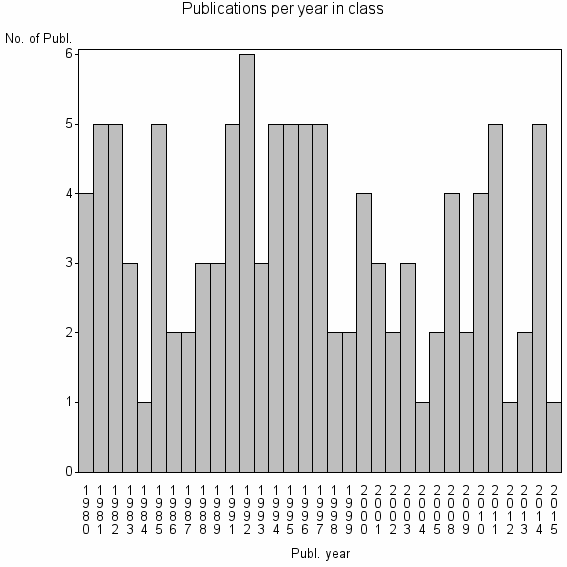
Class information for: |
Basic class information |
| ID | Publications | Average number of references |
Avg. shr. active ref. in WoS |
|---|---|---|---|
| 32281 | 110 | 26.5 | 25% |
Classes in level above (level 2) |
| ID, lev. above |
Publications | Label for level above |
|---|---|---|
| 76 | 26792 | REMOTE SENSING//IMAGING SCIENCE & PHOTOGRAPHIC TECHNOLOGY//REMOTE SENSING OF ENVIRONMENT |
Terms with highest relevance score |
| Rank | Term | Type of term | Relevance score (tfidf) |
Class's shr. of term's tot. occurrences |
Shr. of publ. in class containing term |
Num. of publ. in class |
|---|---|---|---|---|---|---|
| 1 | HISTORICAL IMAGERY | Author keyword | 2 | 67% | 2% | 2 |
| 2 | AERIAL INFRARED THERMOGRAPHY | Author keyword | 1 | 100% | 2% | 2 |
| 3 | CONSERVATION ASSESSMENT AND PLANNING | Author keyword | 1 | 50% | 1% | 1 |
| 4 | DIGITAL ORTHO QUARTER QUADS DOQQ | Author keyword | 1 | 50% | 1% | 1 |
| 5 | MULTIDATE REMOTE SENSING | Author keyword | 1 | 50% | 1% | 1 |
| 6 | REMOTE SENSING IN FORESTRY | Author keyword | 1 | 50% | 1% | 1 |
| 7 | STAT SURVEYS SECT | Address | 1 | 50% | 1% | 1 |
| 8 | STORM SEDIMENT | Author keyword | 1 | 50% | 1% | 1 |
| 9 | THERMAL TRACKING | Author keyword | 1 | 50% | 1% | 1 |
| 10 | LANDFILL MONITORING | Author keyword | 1 | 25% | 2% | 2 |
Web of Science journal categories |
Author Key Words |
Key Words Plus |
| Rank | Web of Science journal category | Relevance score (tfidf) |
Class's shr. of term's tot. occurrences |
Shr. of publ. in class containing term |
Num. of publ. in class |
|---|---|---|---|---|---|
| 1 | DARK FIGURE | 0 | 25% | 1% | 1 |
| 2 | PARTITIONING TRACER METHOD | 0 | 25% | 1% | 1 |
| 3 | SPECTRAL SEPARABILITY | 0 | 20% | 1% | 1 |
| 4 | COVER MAP | 0 | 14% | 1% | 1 |
| 5 | TREELINE DYNAMICS | 0 | 14% | 1% | 1 |
| 6 | ERROR MATRICES | 0 | 13% | 1% | 1 |
| 7 | ENVIRONMENTAL FORENSICS | 0 | 10% | 1% | 1 |
| 8 | HORIZONTAL DIFFUSION | 0 | 10% | 1% | 1 |
| 9 | LANDSAT 7 | 0 | 10% | 1% | 1 |
| 10 | SENSING TOOLS | 0 | 100% | 1% | 1 |
Journals |
Reviews |
| Title | Publ. year | Cit. | Active references |
% act. ref. to same field |
|---|---|---|---|---|
| Visible and Infrared Remote Imaging of Hazardous Waste: A Review | 2010 | 10 | 93 | 17% |
| Requirements for the catchment, treatment, and surveillance of drinking water to avoid the transmittance of pathogenic bacterial, viral, and parasitic organisms | 2001 | 2 | 5 | 20% |
| Critical review of environmental forensic techniques: Part I | 2000 | 17 | 46 | 11% |
| Validating the Remotely Sensed Geography of Crime: A Review of Emerging Issues | 2014 | 0 | 34 | 12% |
Address terms |
| Rank | Address term | Relevance score (tfidf) |
Class's shr. of term's tot. occurrences |
Shr. of publ. in class containing term |
Num. of publ. in class |
|---|---|---|---|---|---|
| 1 | STAT SURVEYS SECT | 1 | 50% | 0.9% | 1 |
| 2 | GEOGR HIE | 0 | 25% | 0.9% | 1 |
| 3 | ENVIRONM PROTECT UNIT | 0 | 17% | 0.9% | 1 |
| 4 | NORWEGIAN RADIAT PROTECT AUTHOR | 0 | 17% | 0.9% | 1 |
| 5 | IND ECOL N | 0 | 14% | 0.9% | 1 |
| 6 | INT PROGRAMS OUTREACH PARTNERSHIPS UNIT | 0 | 100% | 0.9% | 1 |
| 7 | SERV INFROMAT | 0 | 100% | 0.9% | 1 |
| 8 | UFR 08 | 0 | 100% | 0.9% | 1 |
| 9 | URBAN ENGN REG DEV | 0 | 100% | 0.9% | 1 |
Related classes at same level (level 1) |
| Rank | Relatedness score | Related classes |
|---|---|---|
| 1 | 0.0000206722 | YALE CHEM//CONSEQUENCES ANALYSIS//DATA TRANSFERABILITY |
| 2 | 0.0000168767 | ENVIRONMENTALLY SOUND MANAGEMENT//EUROPEAN WASTE LIST//TAIWANS WASTE EXPORT |
| 3 | 0.0000133182 | GLOBAL LAND COVER//SW GEOG SCI//RSU |
| 4 | 0.0000133178 | DEDICATED COMPUTER//SOIL SURFACE TEMPERATURES//CLOUD CORRECTIONS |
| 5 | 0.0000122033 | FORENSIC GEOSCIENCE//FORENSIC PALYNOLOGY//FORENSIC GEOPHYSICS |
| 6 | 0.0000109071 | CLIMATE DRIVEN MODEL//LAND USE SUSTAINABILITY//MOLE TILE DRAINAGE |
| 7 | 0.0000104448 | COLOR INFRARED PHOTOGRAPHY//INTEGRATED FARMING NAT OURCES//CONVENTIONAL COLOR VIDEO IMAGERY |
| 8 | 0.0000098586 | COST CAPACITY FACTOR//WASTE TREATMENT FACILITY//COST CAPACITY FACTORS |
| 9 | 0.0000096727 | FRACTAL MEASUREMENT//OPTIMAL SPATIAL RESOLUTION//RESOLUTION TRANSFORMATION MODEL |
| 10 | 0.0000093028 | CDS COLLOID//ANTI SETTLING//AROMATIC ALIPHATIC CO POLYUREA |