Class information for: |
Basic class information |
| ID | Publications | Average number of references |
Avg. shr. active ref. in WoS |
|---|---|---|---|
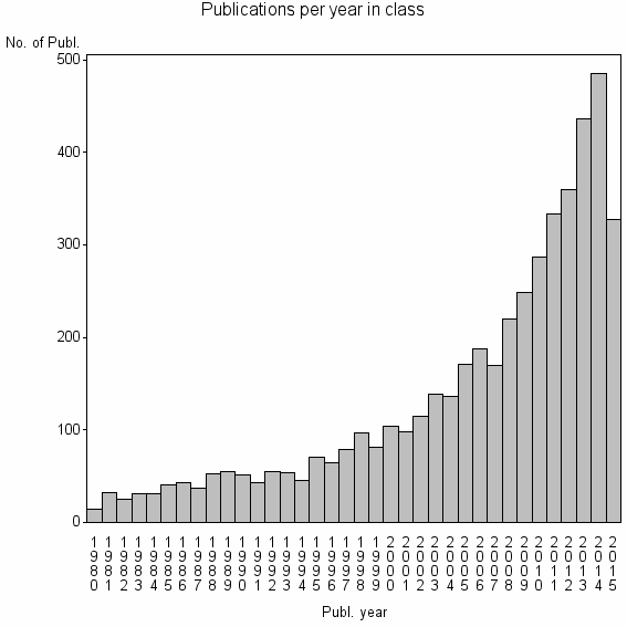
| 2075 | 4808 | 25.8 | 37% |
Classes in level above (level 3) |
| ID, lev. above |
Publications | Label for level above |
|---|---|---|
| 33 | 105593 | COMPUTER SCIENCE, ARTIFICIAL INTELLIGENCE//IEEE TRANSACTIONS ON PATTERN ANALYSIS AND MACHINE INTELLIGENCE//PATTERN RECOGNITION |
Classes in level below (level 1) |
Terms with highest relevance score |
| Rank | Term | Type of term | Relevance score (tfidf) |
Class's shr. of term's tot. occurrences |
Shr. of publ. in class containing term |
Num. of publ. in class |
|---|---|---|---|---|---|---|
| 1 | PHOTOGRAMMETRIC RECORD | Journal | 229 | 58% | 5% | 264 |
| 2 | PHOTOGRAMMETRIC ENGINEERING AND REMOTE SENSING | Journal | 111 | 18% | 11% | 550 |
| 3 | ISPRS JOURNAL OF PHOTOGRAMMETRY AND REMOTE SENSING | Journal | 78 | 23% | 6% | 295 |
| 4 | CARTOG LAND ENGN | Address | 26 | 67% | 0% | 24 |
| 5 | BUILDING EXTRACTION | Author keyword | 25 | 40% | 1% | 48 |
| 6 | CLOSE RANGE PHOTOGRAMMETRY | Author keyword | 23 | 29% | 1% | 68 |
| 7 | HIGH POLYTECH AVILA | Address | 21 | 90% | 0% | 9 |
| 8 | MAT ENGN PL MECH CONSTRUCT | Address | 20 | 62% | 0% | 21 |
| 9 | DIGITAL PHOTOGRAMMETRY | Author keyword | 18 | 27% | 1% | 55 |
| 10 | BUILDING DETECTION | Author keyword | 16 | 35% | 1% | 38 |
Web of Science journal categories |
Author Key Words |
| Rank | Web of Science journal category | Relevance score (tfidf) |
Class's shr. of term's tot. occurrences |
Shr. of publ. in class containing term |
Num. of publ. in class |
LCSH search | Wikipedia search |
|---|---|---|---|---|---|---|---|
| 1 | BUILDING EXTRACTION | 25 | 40% | 1% | 48 | Search BUILDING+EXTRACTION | Search BUILDING+EXTRACTION |
| 2 | CLOSE RANGE PHOTOGRAMMETRY | 23 | 29% | 1% | 68 | Search CLOSE+RANGE+PHOTOGRAMMETRY | Search CLOSE+RANGE+PHOTOGRAMMETRY |
| 3 | DIGITAL PHOTOGRAMMETRY | 18 | 27% | 1% | 55 | Search DIGITAL+PHOTOGRAMMETRY | Search DIGITAL+PHOTOGRAMMETRY |
| 4 | BUILDING DETECTION | 16 | 35% | 1% | 38 | Search BUILDING+DETECTION | Search BUILDING+DETECTION |
| 5 | MOBILE LASER SCANNING | 14 | 48% | 0% | 22 | Search MOBILE+LASER+SCANNING | Search MOBILE+LASER+SCANNING |
| 6 | ROAD NETWORK EXTRACTION | 14 | 65% | 0% | 13 | Search ROAD+NETWORK+EXTRACTION | Search ROAD+NETWORK+EXTRACTION |
| 7 | BUILDING RECONSTRUCTION | 11 | 36% | 1% | 25 | Search BUILDING+RECONSTRUCTION | Search BUILDING+RECONSTRUCTION |
| 8 | TERRESTRIAL LASER SCANNING | 10 | 17% | 1% | 54 | Search TERRESTRIAL+LASER+SCANNING | Search TERRESTRIAL+LASER+SCANNING |
| 9 | LASER SCANNING | 10 | 10% | 2% | 94 | Search LASER+SCANNING | Search LASER+SCANNING |
| 10 | MOBILE LASER SCANNING MLS | 10 | 58% | 0% | 11 | Search MOBILE+LASER+SCANNING+MLS | Search MOBILE+LASER+SCANNING+MLS |
Key Words Plus |
| Rank | Web of Science journal category | Relevance score (tfidf) |
Class's shr. of term's tot. occurrences |
Shr. of publ. in class containing term |
Num. of publ. in class |
|---|---|---|---|---|---|
| 1 | RATIONAL FUNCTION MODEL | 52 | 82% | 1% | 31 |
| 2 | AERIAL IMAGES | 46 | 45% | 2% | 77 |
| 3 | POINT CLOUDS | 37 | 39% | 2% | 73 |
| 4 | SENSOR ORIENTATION | 35 | 76% | 1% | 25 |
| 5 | AERIAL IMAGERY | 29 | 49% | 1% | 42 |
| 6 | PHOTOGRAMMETRY | 24 | 23% | 2% | 90 |
| 7 | GEOPOSITIONING ACCURACY | 23 | 76% | 0% | 16 |
| 8 | SPOT IMAGERY | 23 | 60% | 1% | 25 |
| 9 | CENTERLINES | 21 | 85% | 0% | 11 |
| 10 | DEPOSITION VOLUMES | 19 | 58% | 0% | 22 |
Journals |
| Rank | Web of Science journal category | Relevance score (tfidf) |
Class's shr. of term's tot. occurrences |
Shr. of publ. in class containing term |
Num. of publ. in class |
|---|---|---|---|---|---|
| 1 | PHOTOGRAMMETRIC RECORD | 229 | 58% | 5% | 264 |
| 2 | PHOTOGRAMMETRIC ENGINEERING AND REMOTE SENSING | 111 | 18% | 11% | 550 |
| 3 | ISPRS JOURNAL OF PHOTOGRAMMETRY AND REMOTE SENSING | 78 | 23% | 6% | 295 |
| 4 | PHOTOGRAMMETRIE FERNERKUNDUNG GEOINFORMATION | 16 | 24% | 1% | 57 |
| 5 | PHOTOGRAMMETRIA | 11 | 34% | 1% | 27 |
| 6 | BOLETIM DE CIENCIAS GEODESICAS | 7 | 17% | 1% | 39 |
| 7 | EUROPEAN JOURNAL OF REMOTE SENSING | 3 | 13% | 0% | 20 |
Reviews |
| Title | Publ. year | Cit. | Active references |
% act. ref. to same field |
|---|---|---|---|---|
| Unmanned aerial systems for photogrammetry and remote sensing: A review | 2014 | 33 | 17 | 35% |
| Review article: Geometric processing of remote sensing images: models, algorithms and methods | 2004 | 190 | 31 | 87% |
| Lightweight unmanned aerial vehicles will revolutionize spatial ecology | 2013 | 47 | 38 | 42% |
| A comprehensive review of earthquake-induced building damage detection with remote sensing techniques | 2013 | 16 | 54 | 78% |
| Review of mobile mapping and surveying technologies | 2013 | 19 | 27 | 63% |
| Photogrammetric techniques in civil engineering material testing and structure monitoring | 2006 | 49 | 1 | 100% |
| Development and Status of Image Matching in Photogrammetry | 2012 | 24 | 22 | 64% |
| CityGML - Interoperable semantic 3D city models | 2012 | 23 | 26 | 65% |
| Digital camera self-calibration | 1997 | 165 | 6 | 50% |
| State of the art on automatic road extraction for GIS update: a novel classification | 2003 | 148 | 51 | 59% |
Address terms |
| Rank | Address term | Relevance score (tfidf) |
Class's shr. of term's tot. occurrences |
Shr. of publ. in class containing term |
Num. of publ. in class |
|---|---|---|---|---|---|
| 1 | CARTOG LAND ENGN | 26 | 67% | 0.5% | 24 |
| 2 | HIGH POLYTECH AVILA | 21 | 90% | 0.2% | 9 |
| 3 | MAT ENGN PL MECH CONSTRUCT | 20 | 62% | 0.4% | 21 |
| 4 | NAT OURCES ENVIRONM ENGN | 15 | 24% | 1.1% | 55 |
| 5 | CLOSE RANGE REMOTE SENSING PHOTOGRAMMETRY GRP | 15 | 77% | 0.2% | 10 |
| 6 | SATELLITE SURVEYING M PING PLICAT | 14 | 64% | 0.3% | 14 |
| 7 | REMOTE SENSING INFORMAT ENGN | 12 | 21% | 1.0% | 50 |
| 8 | CYBER ARCHAEOL | 12 | 86% | 0.1% | 6 |
| 9 | LAND CARTOG ENGN | 12 | 86% | 0.1% | 6 |
| 10 | GEOMAT ENGN | 11 | 10% | 2.1% | 99 |
Related classes at same level (level 2) |