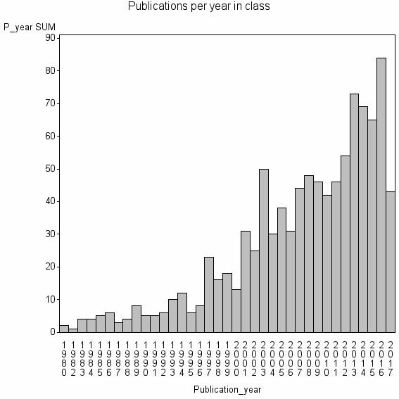
Class information for: |
Basic class information |

Hierarchy of classes |
The table includes all classes above and classes immediately below the current class. |
Terms with highest relevance score |
| rank | Category | termType | chi_square | shrOfCwithTerm | shrOfTermInClass | termInClass |
|---|---|---|---|---|---|---|
| 1 | BATHYMETRY | authKW | 316356 | 9% | 11% | 86 |
| 2 | BIOPHYS REMOTE SENSING GRP | address | 202431 | 2% | 37% | 17 |
| 3 | WATER COLUMN CORRECTION | authKW | 193346 | 1% | 100% | 6 |
| 4 | BATHYMETRIC LIDAR | authKW | 186434 | 1% | 64% | 9 |
| 5 | MARINE REMOTE SENSING | address | 179070 | 2% | 33% | 17 |
| 6 | SATELLITE DERIVED BATHYMETRY | authKW | 161121 | 1% | 100% | 5 |
| 7 | BATHYMETRIC MAPPING | authKW | 112778 | 1% | 50% | 7 |
| 8 | DEPTH RETRIEVAL | authKW | 100697 | 1% | 63% | 5 |
| 9 | LIGHT DETECTION AND RANGING LIDAR BATHYMETRY | authKW | 96673 | 0% | 100% | 3 |
| 10 | SPATIAL ENVIRONM | address | 92930 | 2% | 19% | 15 |
Web of Science journal categories |
| chi_square_rank | Category | chi_square | shrOfCwithTerm | shrOfTermInClass | termInClass |
|---|---|---|---|---|---|
| 1 | Remote Sensing | 86931 | 41% | 1% | 403 |
| 2 | Imaging Science & Photographic Technology | 46623 | 31% | 0% | 304 |
| 3 | Geography, Physical | 19105 | 24% | 0% | 232 |
| 4 | Geosciences, Multidisciplinary | 4386 | 25% | 0% | 246 |
| 5 | Oceanography | 2828 | 12% | 0% | 121 |
| 6 | Environmental Sciences | 2283 | 25% | 0% | 240 |
| 7 | Marine & Freshwater Biology | 1800 | 13% | 0% | 128 |
| 8 | Water Resources | 738 | 8% | 0% | 78 |
| 9 | Limnology | 707 | 3% | 0% | 33 |
| 10 | Engineering, Ocean | 548 | 2% | 0% | 20 |
Address terms |
| chi_square_rank | term | chi_square | shrOfCwithTerm | shrOfTermInClass | termInClass |
|---|---|---|---|---|---|
| 1 | BIOPHYS REMOTE SENSING GRP | 202431 | 2% | 37% | 17 |
| 2 | MARINE REMOTE SENSING | 179070 | 2% | 33% | 17 |
| 3 | SPATIAL ENVIRONM | 92930 | 2% | 19% | 15 |
| 4 | REMOTE SENSING SATELLITE GRP | 73644 | 1% | 29% | 8 |
| 5 | CPE COASTAL GEOL GEOMAT | 72503 | 0% | 75% | 3 |
| 6 | GEOSENSING SYST ENGN SCI | 64449 | 0% | 100% | 2 |
| 7 | REMOTE SENSING SPATIAL INFORMAT SCI | 60906 | 1% | 17% | 11 |
| 8 | GEOMORPHOL SEDIMENT TRANSPORT | 58912 | 1% | 23% | 8 |
| 9 | TROP COASTAL MANAGEMENT STUDIES | 57995 | 1% | 30% | 6 |
| 10 | COASTAL PLANNING ENGN | 42964 | 0% | 67% | 2 |
Journals |
| chi_square_rank | term | chi_square | shrOfCwithTerm | shrOfTermInClass | termInClass |
|---|---|---|---|---|---|
| 1 | INTERNATIONAL JOURNAL OF REMOTE SENSING | 31754 | 10% | 1% | 98 |
| 2 | EARTH SURFACE PROCESSES AND LANDFORMS | 24061 | 5% | 1% | 52 |
| 3 | PHOTOGRAMMETRIC RECORD | 21229 | 2% | 4% | 18 |
| 4 | REMOTE SENSING | 19788 | 5% | 1% | 50 |
| 5 | REMOTE SENSING OF ENVIRONMENT | 16866 | 6% | 1% | 58 |
| 6 | JOURNAL OF COASTAL RESEARCH | 16058 | 6% | 1% | 56 |
| 7 | PHOTOGRAMMETRIC ENGINEERING AND REMOTE SENSING | 12559 | 4% | 1% | 35 |
| 8 | CORAL REEFS | 10386 | 3% | 1% | 26 |
| 9 | RIVER RESEARCH AND APPLICATIONS | 9554 | 2% | 1% | 21 |
| 10 | JOURNAL OF APPLIED REMOTE SENSING | 6482 | 2% | 1% | 18 |
Author Key Words |
Core articles |
The table includes core articles in the class. The following variables is taken into account for the relevance score of an article in a cluster c: (1) Number of references referring to publications in the class. (2) Share of total number of active references referring to publications in the class. (3) Age of the article. New articles get higher score than old articles. (4) Citation rate, normalized to year. |
Classes with closest relation at Level 1 |