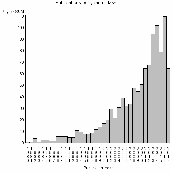
Class information for: |
Basic class information |

Hierarchy of classes |
The table includes all classes above and classes immediately below the current class. |
Terms with highest relevance score |
| rank | Category | termType | chi_square | shrOfCwithTerm | shrOfTermInClass | termInClass |
|---|---|---|---|---|---|---|
| 1 | CHANGE DETECTION | authKW | 2325288 | 35% | 21% | 371 |
| 2 | UNSUPERVISED CHANGE DETECTION | authKW | 649200 | 2% | 96% | 23 |
| 3 | MULTITEMPORAL IMAGES | authKW | 565025 | 3% | 71% | 27 |
| 4 | CHANGE VECTOR ANALYSIS CVA | authKW | 339575 | 1% | 82% | 14 |
| 5 | CHANGE DETECTION CD | authKW | 327819 | 1% | 70% | 16 |
| 6 | REMOTE SENSING | WoSSC | 265999 | 69% | 1% | 736 |
| 7 | CHANGE VECTOR ANALYSIS | authKW | 245432 | 1% | 56% | 15 |
| 8 | RELATIVE RADIOMETRIC NORMALIZATION | authKW | 235627 | 1% | 100% | 8 |
| 9 | DIFFERENCE IMAGE | authKW | 215413 | 1% | 46% | 16 |
| 10 | IMAGING SCIENCE & PHOTOGRAPHIC TECHNOLOGY | WoSSC | 193642 | 60% | 1% | 646 |
Web of Science journal categories |
| chi_square_rank | Category | chi_square | shrOfCwithTerm | shrOfTermInClass | termInClass |
|---|---|---|---|---|---|
| 1 | Remote Sensing | 265999 | 69% | 1% | 736 |
| 2 | Imaging Science & Photographic Technology | 193642 | 60% | 1% | 646 |
| 3 | Geography, Physical | 8719 | 15% | 0% | 165 |
| 4 | Geochemistry & Geophysics | 4532 | 18% | 0% | 197 |
| 5 | Engineering, Electrical & Electronic | 2194 | 28% | 0% | 300 |
| 6 | Geosciences, Multidisciplinary | 1048 | 12% | 0% | 133 |
| 7 | Environmental Sciences | 928 | 16% | 0% | 169 |
| 8 | Computer Science, Artificial Intelligence | 683 | 7% | 0% | 77 |
| 9 | Forestry | 95 | 2% | 0% | 21 |
| 10 | Geography | 33 | 1% | 0% | 11 |
Address terms |
| chi_square_rank | term | chi_square | shrOfCwithTerm | shrOfTermInClass | termInClass |
|---|---|---|---|---|---|
| 1 | JOINT SPATIAL INFORMAT | 140244 | 1% | 48% | 10 |
| 2 | COMP VIS PATTERN DISCOVERY GRP | 88360 | 0% | 100% | 3 |
| 3 | DEF PEACE SAFETY SECUR UNIT | 66269 | 0% | 75% | 3 |
| 4 | INTELLIGENT PERCEPT IMAGE UNDERSTANDING | 62473 | 4% | 6% | 38 |
| 5 | ENVIRONM LAND USE PLANNING | 58907 | 0% | 100% | 2 |
| 6 | GEOMAT FO T ENGN GRP | 58907 | 0% | 100% | 2 |
| 7 | MERAKA | 45672 | 1% | 14% | 11 |
| 8 | JIANGSU PROV OURCES ENVIRONM INFORMA | 39270 | 0% | 67% | 2 |
| 9 | SPATIAL TECHNOL | 39270 | 0% | 67% | 2 |
| 10 | REMOTE SENSING UNIT | 39171 | 1% | 10% | 13 |
Journals |
| chi_square_rank | term | chi_square | shrOfCwithTerm | shrOfTermInClass | termInClass |
|---|---|---|---|---|---|
| 1 | INTERNATIONAL JOURNAL OF REMOTE SENSING | 91713 | 16% | 2% | 174 |
| 2 | IEEE GEOSCIENCE AND REMOTE SENSING LETTERS | 53799 | 7% | 2% | 79 |
| 3 | IEEE TRANSACTIONS ON GEOSCIENCE AND REMOTE SENSING | 38378 | 10% | 1% | 110 |
| 4 | PHOTOGRAMMETRIC ENGINEERING AND REMOTE SENSING | 30500 | 5% | 2% | 57 |
| 5 | IEEE JOURNAL OF SELECTED TOPICS IN APPLIED EARTH OBSERVATIONS AND REMOTE SENSING | 28539 | 4% | 2% | 48 |
| 6 | JOURNAL OF APPLIED REMOTE SENSING | 22454 | 3% | 2% | 35 |
| 7 | ISPRS JOURNAL OF PHOTOGRAMMETRY AND REMOTE SENSING | 22026 | 3% | 2% | 35 |
| 8 | REMOTE SENSING LETTERS | 21241 | 2% | 3% | 23 |
| 9 | REMOTE SENSING | 12141 | 4% | 1% | 41 |
| 10 | REMOTE SENSING OF ENVIRONMENT | 10535 | 4% | 1% | 48 |
Author Key Words |
Core articles |
The table includes core articles in the class. The following variables is taken into account for the relevance score of an article in a cluster c: (1) Number of references referring to publications in the class. (2) Share of total number of active references referring to publications in the class. (3) Age of the article. New articles get higher score than old articles. (4) Citation rate, normalized to year. |
Classes with closest relation at Level 1 |