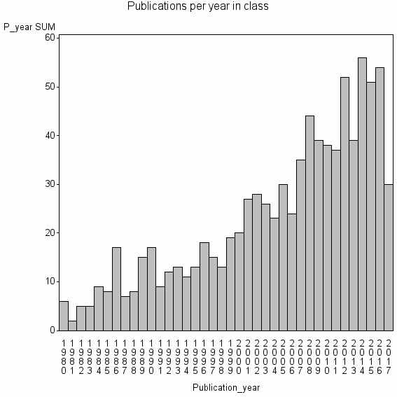
Class information for: |
Basic class information |

Hierarchy of classes |
The table includes all classes above and classes immediately below the current class. |
Terms with highest relevance score |
| rank | Category | termType | chi_square | shrOfCwithTerm | shrOfTermInClass | termInClass |
|---|---|---|---|---|---|---|
| 1 | FOREST INVENTORY | authKW | 338361 | 9% | 11% | 83 |
| 2 | NEAREST NEIGHBOR IMPUTATION | authKW | 153668 | 1% | 53% | 8 |
| 3 | PLOT LOCATION ERROR | authKW | 108053 | 0% | 100% | 3 |
| 4 | K NN METHOD | authKW | 100045 | 1% | 56% | 5 |
| 5 | REMOTE SENSING | WoSSC | 91529 | 45% | 1% | 391 |
| 6 | BIOFOR ITALY SRL | address | 72035 | 0% | 100% | 2 |
| 7 | FOREST CARBON MAPPING | authKW | 72035 | 0% | 100% | 2 |
| 8 | FOREST STRUCTURAL ATTRIBUTES | authKW | 72035 | 0% | 100% | 2 |
| 9 | IMAGE SPATIAL ANALYSIS | authKW | 72035 | 0% | 100% | 2 |
| 10 | K MOST SIMILAR NEIGHBORS | authKW | 72035 | 0% | 100% | 2 |
Web of Science journal categories |
| chi_square_rank | Category | chi_square | shrOfCwithTerm | shrOfTermInClass | termInClass |
|---|---|---|---|---|---|
| 1 | Remote Sensing | 91529 | 45% | 1% | 391 |
| 2 | Imaging Science & Photographic Technology | 64967 | 39% | 1% | 339 |
| 3 | Forestry | 37550 | 37% | 0% | 321 |
| 4 | Geography, Physical | 3787 | 11% | 0% | 99 |
| 5 | Environmental Sciences | 1233 | 20% | 0% | 171 |
| 6 | Geosciences, Multidisciplinary | 588 | 11% | 0% | 92 |
| 7 | Ecology | 124 | 5% | 0% | 47 |
| 8 | Agriculture, Multidisciplinary | 55 | 2% | 0% | 18 |
| 9 | Geochemistry & Geophysics | 11 | 2% | 0% | 15 |
| 10 | Geography | 9 | 1% | 0% | 6 |
Address terms |
| chi_square_rank | term | chi_square | shrOfCwithTerm | shrOfTermInClass | termInClass |
|---|---|---|---|---|---|
| 1 | BIOFOR ITALY SRL | 72035 | 0% | 100% | 2 |
| 2 | SCI SERV NFI | 48022 | 0% | 67% | 2 |
| 3 | SECT FO T OURCE ANAL | 48022 | 0% | 67% | 2 |
| 4 | SURVEY PLANNING | 48022 | 0% | 67% | 2 |
| 5 | UNITA RIC MONITORAGGIO PIANIFICAZ FO TALE CRA | 48022 | 0% | 67% | 2 |
| 6 | ZAKLAD GEOINFORMAT KARTOG TELEDETEKCJI | 48022 | 0% | 67% | 2 |
| 7 | AGROFO TRY ENGNESCOLA POLITECN SUPER | 36018 | 0% | 100% | 1 |
| 8 | ARILAND ENGN | 36018 | 0% | 100% | 1 |
| 9 | BC MINIST FO T BRANCH | 36018 | 0% | 100% | 1 |
| 10 | CAWANGAN SABAH | 36018 | 0% | 100% | 1 |
Journals |
| chi_square_rank | term | chi_square | shrOfCwithTerm | shrOfTermInClass | termInClass |
|---|---|---|---|---|---|
| 1 | REMOTE SENSING OF ENVIRONMENT | 56222 | 11% | 2% | 100 |
| 2 | INTERNATIONAL JOURNAL OF REMOTE SENSING | 48946 | 13% | 1% | 115 |
| 3 | PHOTOGRAMMETRIC ENGINEERING AND REMOTE SENSING | 37323 | 7% | 2% | 57 |
| 4 | SILVA FENNICA | 19789 | 3% | 3% | 22 |
| 5 | SCANDINAVIAN JOURNAL OF FOREST RESEARCH | 18919 | 4% | 2% | 32 |
| 6 | JOURNAL OF FORESTRY | 13973 | 3% | 1% | 28 |
| 7 | FOREST SCIENCE | 9502 | 3% | 1% | 27 |
| 8 | IFOREST-BIOGEOSCIENCES AND FORESTRY | 8592 | 1% | 2% | 12 |
| 9 | FOREST ECOLOGY AND MANAGEMENT | 8465 | 6% | 0% | 53 |
| 10 | CANADIAN JOURNAL OF REMOTE SENSING | 5465 | 1% | 1% | 12 |
Author Key Words |
Core articles |
The table includes core articles in the class. The following variables is taken into account for the relevance score of an article in a cluster c: (1) Number of references referring to publications in the class. (2) Share of total number of active references referring to publications in the class. (3) Age of the article. New articles get higher score than old articles. (4) Citation rate, normalized to year. |
Classes with closest relation at Level 1 |