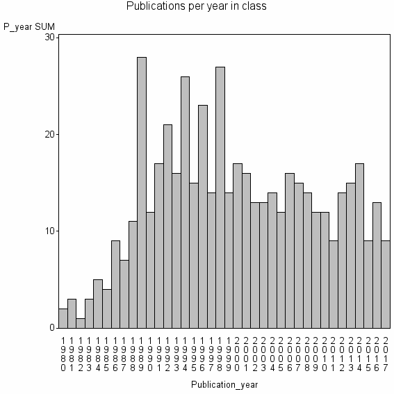
Class information for: |
Basic class information |

Hierarchy of classes |
The table includes all classes above and classes immediately below the current class. |
Terms with highest relevance score |
| rank | Category | termType | chi_square | shrOfCwithTerm | shrOfTermInClass | termInClass |
|---|---|---|---|---|---|---|
| 1 | OPTIMAL SPATIAL RESOLUTION | authKW | 253143 | 1% | 100% | 4 |
| 2 | HBEREICH GEOG GEOWISSEN | address | 143826 | 1% | 45% | 5 |
| 3 | FRACTAL MEASUREMENT | authKW | 142391 | 1% | 75% | 3 |
| 4 | GEOSTATISTICAL CLASSIFICATION | authKW | 126571 | 0% | 100% | 2 |
| 5 | ISARITHM | authKW | 126571 | 0% | 100% | 2 |
| 6 | ISARITHM METHOD | authKW | 126571 | 0% | 100% | 2 |
| 7 | MAP COMPARISON INTEGRATION | authKW | 126571 | 0% | 100% | 2 |
| 8 | TRIANGULAR PRISM METHOD | authKW | 126571 | 0% | 100% | 2 |
| 9 | VARIO FUNCTIONS | authKW | 126571 | 0% | 100% | 2 |
| 10 | DIVIDER METHOD | authKW | 112503 | 1% | 44% | 4 |
Web of Science journal categories |
| chi_square_rank | Category | chi_square | shrOfCwithTerm | shrOfTermInClass | termInClass |
|---|---|---|---|---|---|
| 1 | Remote Sensing | 46366 | 42% | 0% | 210 |
| 2 | Imaging Science & Photographic Technology | 36615 | 39% | 0% | 192 |
| 3 | Geography, Physical | 4638 | 16% | 0% | 82 |
| 4 | Geosciences, Multidisciplinary | 3585 | 32% | 0% | 157 |
| 5 | Geography | 1143 | 7% | 0% | 36 |
| 6 | Computer Science, Interdisciplinary Applications | 379 | 8% | 0% | 40 |
| 7 | Mathematics, Interdisciplinary Applications | 324 | 6% | 0% | 31 |
| 8 | Environmental Sciences | 227 | 12% | 0% | 60 |
| 9 | Oceanography | 174 | 5% | 0% | 23 |
| 10 | Geochemistry & Geophysics | 124 | 5% | 0% | 25 |
Address terms |
| chi_square_rank | term | chi_square | shrOfCwithTerm | shrOfTermInClass | termInClass |
|---|---|---|---|---|---|
| 1 | HBEREICH GEOG GEOWISSEN | 143826 | 1% | 45% | 5 |
| 2 | SPACE SCI TECHNOL GLOBAL HYDROL CLIM | 84380 | 0% | 67% | 2 |
| 3 | ADV FO T TECHNOL PROGRAM CANADIAN FO T SERV | 63286 | 0% | 100% | 1 |
| 4 | AGRIRS AGR OURCES REG PLANNING | 63286 | 0% | 100% | 1 |
| 5 | ARCTIC ALPINE CAMPUS BOX 450 | 63286 | 0% | 100% | 1 |
| 6 | BIOSTATIST PROCESSUS SPATIAUX | 63286 | 0% | 100% | 1 |
| 7 | CENTRO ESTUDIO RECURSOS NATUR OTERRA | 63286 | 0% | 100% | 1 |
| 8 | CIBOLA FO T | 63286 | 0% | 100% | 1 |
| 9 | E66W REMOTE SENSING | 63286 | 0% | 100% | 1 |
| 10 | EARTH SCI SURVEY CARTOG ENGN | 63286 | 0% | 100% | 1 |
Journals |
| chi_square_rank | term | chi_square | shrOfCwithTerm | shrOfTermInClass | termInClass |
|---|---|---|---|---|---|
| 1 | INTERNATIONAL JOURNAL OF REMOTE SENSING | 65133 | 20% | 1% | 100 |
| 2 | MATHEMATICAL GEOLOGY | 19662 | 4% | 2% | 18 |
| 3 | COMPUTERS & GEOSCIENCES | 18163 | 7% | 1% | 35 |
| 4 | PHOTOGRAMMETRIC ENGINEERING AND REMOTE SENSING | 12604 | 5% | 1% | 25 |
| 5 | REMOTE SENSING OF ENVIRONMENT | 10088 | 6% | 1% | 32 |
| 6 | AMERICAN CARTOGRAPHER | 8501 | 1% | 3% | 4 |
| 7 | JOURNAL OF THE INTERNATIONAL ASSOCIATION FOR MATHEMATICAL GEOLOGY | 2619 | 1% | 1% | 3 |
| 8 | ISPRS JOURNAL OF PHOTOGRAMMETRY AND REMOTE SENSING | 2464 | 2% | 0% | 8 |
| 9 | PHOTOGRAMMETRIE FERNERKUNDUNG GEOINFORMATION | 2143 | 1% | 1% | 3 |
| 10 | CHINESE GEOGRAPHICAL SCIENCE | 1675 | 1% | 1% | 5 |
Author Key Words |
Core articles |
The table includes core articles in the class. The following variables is taken into account for the relevance score of an article in a cluster c: (1) Number of references referring to publications in the class. (2) Share of total number of active references referring to publications in the class. (3) Age of the article. New articles get higher score than old articles. (4) Citation rate, normalized to year. |
Classes with closest relation at Level 1 |