
Groundwater in peri-urban areas
Modelling and visualization of pollutant transport in peri-urban areas of shallow groundwater table and development of a decision aid system for evaluating remediation and prevention schemes.
Project leaders: Roger Thunvik, Berit Balfors
Participants: Emma Engström
Key words: Peri-urban, Uganda, Shallow groundwater, Contaminant transport, Protected Areas, Sanitation, Remediation
Project period: 2009 – 2013
Funding: Excellent graduate student grant from KTH Royal Institute of Technology (School of Architecture and Built Environment), Stockholm, Sweden
Project description
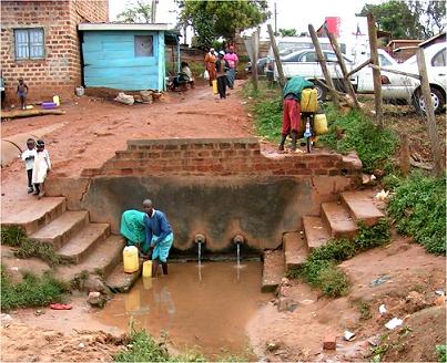
Peri-urban residents in developing countries commonly use shallow groundwater for domestic purposes and drinking water, as it is free of charge. However, this is associated with health risks, as the environment of peri-urban areas is often polluted, due to high contaminant generation, as population density is high and sanitation facilities and solid waste management systems are inadequate.
Bwaise III Parish, an inhabited wetland within the Lubigi catchment draining into Lake Mayanja, is a typical peri-urban region in Kampala, Uganda, as it is densely populated (more than 27,000 inhabitants/km2), has informal settlements and a low income population. The withdrawal of water from groundwater fed, so called, “protected springs” is common. However, the water from these springs is often contaminated and a link has been established between the use of contaminated water from the protected springs and the incidence of acute diarrhoea and cholera. Moreover, disease outbreak after heavy rains is especially common due to flooding and poor sanitation.
In order to improve public health it is imperative to better understand the pollutant subsurface transport to the protected springs. This can be facilitated by conceptual and numerical modelling. However, existing models need to be supplemented in order to more correctly reflect the peri-urban, shallow groundwater conditions. The modelling is complicated by, for example, the presence of macropores in the unsaturated areas, due to anthropogenic waste in the ground; the boundary conditions that are in the form of drains; and the transport mechanisms for different kinds of pollutants, e.g. phosphorous, bacteria and toxic metals.
Aim
The aim of the first part of the project is to improve current numerical modelling to better describe the contaminant transport and hence to find: the travel time of contaminants to the groundwater table; the water table response to different rainfall rates; and the time it takes to naturally restore polluted land. The project builds on extensive earlier research in the area, particularly by Robinah Kulabako from the Makerere University, Kampala.
The objective of the second part is to evaluate different prevention and remediation schemes, as regards protection areas delimitation, location and improvement, e.g. by using selected materials in low-cost filters to faster remove contaminants. As these initiatives also have societal, economical and legal implications, decisions aid systems, such as Multiple-Criteria Decision Analysis (MCDA), will be developed, in accordance with the EU Water Framework Directive and its emphasis on integrated water resources management.
Cooperation
This thesis project is implemented in collaboration with the Environmental Management and Assessment research group, KTH, and the Makerere University researchers Robinha Kulabako, Ronald Musenze and Joel Kinobe, engaged in the Sida/SAREC-funded co-operation project “Sustainable Technological Developlment in the Lake Victoria Region”.