
SCALMIN 2 – field work at Qullissat, Western Greenland
SCALMIN 2 is the acronym for the second phase of the field work in the research project Sustainable Communities and the Legacies of Mining in the Nordic Arctic, which took place at Ilulissat and Qullissat in Western Greenland August 3-15, 2015.
Introduction
The objective of the SCALMIN 2 field work at Ilulissat and Qullissat was to understand how different actors in Greenland today (locally and reionally) deal with the material and immaterial legacies of Qullissat, what importance and narratives they attach to the site, and how different actors use it. The fieldwork sought to answer the following questions:
- What is the nature of the material remains of Qullissat today?
- What parts of the settlements has been removed or changed since the mining operations closed, and why?
- What meanings and values are inscribed upon the built environment of Qullissat by the community of Greenlanders who used to live and work there, by entrepreneurs within the tourism industry, and by policy makers at local and national levels?
- How do different stakeholders use the site today, and why?
With mining becoming an important component of debates about Greenland’s future – and increasingly tied to debates over the relationship between mining and Greenlandic identity – Qullissat provides a unique and invaluable window into the relations between indigenous Greenlanders and the construction of economic and social futures.
Fieldwork tasks
At Qullissat the fieldwork team surveyed and documented cultural remains, made maps, plans and inventories and conducted a number of interviews with former residents at Qullissat as well as planners and decision makers whose task it is to manage or in other ways deal with the remains of Qullissat. The results will serve as a basis for comparative research of the other focal sites of the project at Norrbotten and Svalbard.
The researchers were based in a field camp inside a building offered by two members of the diaspora community. We are very grateful for their kind contribution to our fieldwork and even more so for their contribution of first-hand knowledge on how the site is being re-used today. The team used camping and security equipment provided by the Swedish Polar Research Secretariat, which supported the expedition as part of their SWEDARCTIC 2015 program.
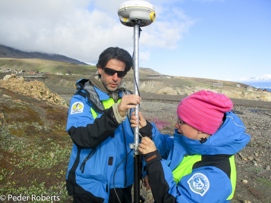
The fieldwork was a multinational undertaking, involving researchers and doctoral candidates based in Sweden and Denmark. The researchers worked in three different teams, two at Qullissat and one at Ilulissat. The teams working at Qullissat performed GNSS/GPS mapping, drawings, text descriptions, and photo documentation.
Laying the foundation – designating feature numbers
We started the field research at Qullissat by making a joint overarching survey of the settlement and mines, in order to designate feature numbers to the different houses, infrastructures and artefacts at the site. These feature numbers were placed on an aerial photograph from 1958, which we used as a base for field documentation. The project acknowledges the invaluable support of Asiaq Greenland Survey, who provided the aerial photograph to the project with no charge. The team defined over 400 features, which we documented through the fieldwork tasks described below.
GNSS/GPS mapping
The task of conducting GNSS/GPS mapping required two persons. The original work plan involved two GNSSS/GPS units, but since only one of the GNNS/GPS receivers functioned in a satisfactory way the plan was altered. The mappers recorded the positions of key features in the settlement, used as a tool to geo-reference the above-mentioned aerial photographs. The resulting map of Qullissat is the basis for our report on the site.
Drawings
A second task of great importance was to make drawings of the individual features, providing accurate representations of those features that the GNSS/GPS technology we used cannot provide. We did so using the simplest of archaeological technology – paper and pen and a 50m measuring tape.

Text descriptions
The third task was to make text descriptions of all features. These contain not only facts on building style, materials, decorations, furniture, and more, but also interpretations and reflections by the researchers. This task always involved discussions among all team members, allowing for more input and reflection on how to interpret material culture.
Photo documentation
The fourth task consisted of photo documentation. This involved overview photographs, photos depicting spatial and production relationships, as well as photos of individual features and of details. The photographs are a fundamental component of the site documentation, allowing for additional interpretations and observations off-site.
Interviews
The fifth fieldwork task was the interviews. Prior to the field campaign, team members constructed an interview guide, providing the main questions and themes to be addressed. The interviews were carried out using notebook and dictaphone.
The team members
Team 1 (Qullissat):
Dag Avango, Researcher, KTH: Photography, expedition leader
Peder Roberts, Researcher, KTH: Text descriptions
Corinna Röver, PhD student, KTH: Drawings
Team 2 (Qullissat):
Hanna Vikström, PhD student, KTH: Photography, GPS mapping
Janina Priebe, PhD student, Umeå University: Text descriptions
Eric Paglia, PhD student, KTH: Drawings, GPS mapping
Team 3 (Ilulissat):
Anne-Mette Jørgensen, PhD student,
University of Copenhagen and
National Museum of Denmark: Interviews
Sofie Andersen, Translator Translation of interviews from Danish to Greenlandic
Expedition narrative
Ilulissat phase
Dag Avango, Peder Roberts, Anne-Mette Jørgensen, Janina Priebe and Hanna Vikström arrived in Ilulissat in the late afternoon of August 3. The following day the team participated in an academic workshop in collaboration with the History of Norwegian Polar Politics (led by Einar-Arne Drivenes and Stian Bones, University of Tromsø) and began planning the research tasks at Ilulissat. August 5-6 team members conducted field work in Ilulissat, studying how the region is promoted and narrated by authorities, the tourism industry, museums and the Ilulissat world heritage site management. On August 7 two additional expedition members joined the team – Eric Paglia and Corinna Röver – and logistical preparations were completed.
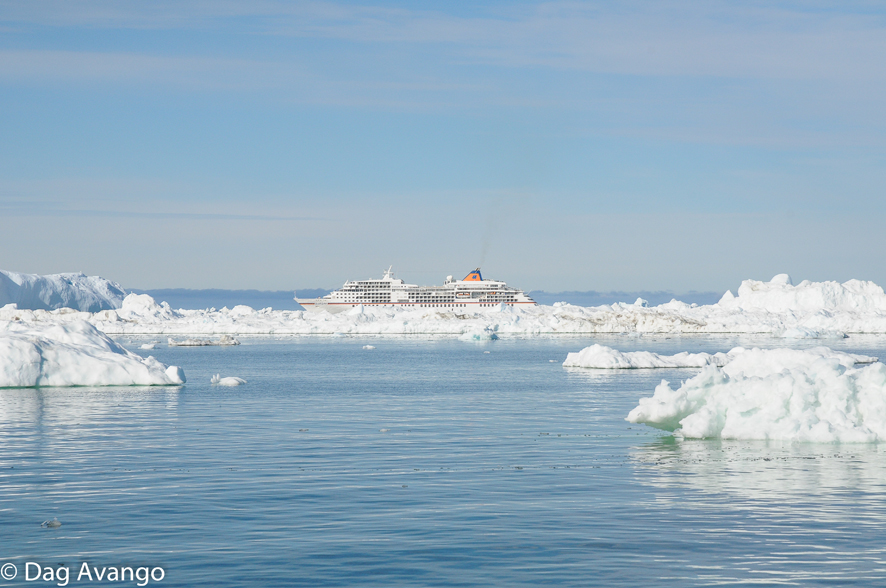
Fig. 12. Tourism at Ilulissat tends to focus on the large amount of ice bergs released by the nearby glacier Sermeq Kujalleq and associated narratives about the environmental impacts of climate change. Only one of the many local tour operators take tourists to visit Qullissat.
Qullissat phase
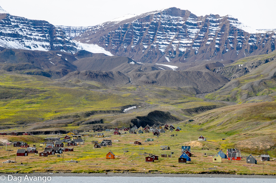
On early August 8 the team loaded all equipment into a chartered vessel and sailed approximately 100km to Qullissat. The trip took longer than expected due to poor weather conditions and an engine failure aboard the boat, but upon arrival at Qullissat the team were able to successfully land their equipment and establish a tent camp near the Forsamlingshus (meeting house) in the middle of the settlement. The team began the task of defining features for the rest of the day and in the evening accepted an invitation to sleep in the Forsamlingshus instead of the tents, in order to avoid the necessity of a nighttime polar bear watch.

From August 9 to 11, the field work teams documented the entire northern part of the settlement, approximately 350 features, mostly consisting of buildings or remains of buildings for housing and various service functions – hospital, school and meeting halls. The amount of remains was larger than expected, which forced the team to work into the evenings.
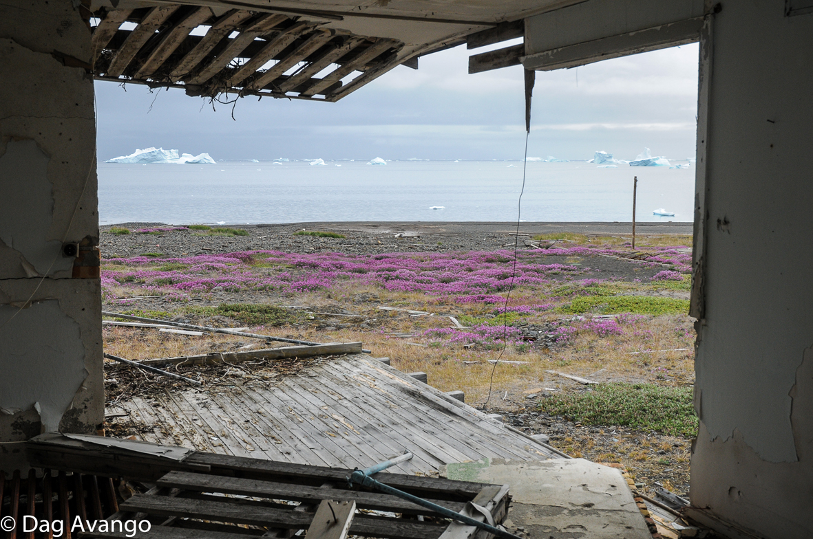
The final fieldwork days were spent documenting the southern part of the settlement and the mining area. Southern Qullissat was fundamentally different from the northern part, where most buildings consist of former family housing. Most of the building remains in the northern area had either been used as workers barracks or had been part of the production system. No one was re-using any of the buildings in the southern part of the settlement, although graffiti on the walls indicate many visitors, including the Aussivik youth meetings in the late 1970’s.
On the last day at Qullissat, August 13, the team documented the mining area, which is located close to the coastline about a kilometer south of the town. Avango and Roberts also conducted interviews with former Qullissat residents who were visiting the site.
After working very late and from early morning of August 14, our ship arrived by midday and transported the team back to Ilulissat. A very successful fieldwork campaign was celebrated with a dinner of fresh seafood at Hotel Arctic. The following day the entire team travelled back to Denmark and Sweden.
Results
The results from the field work at Qullissat is being organized and turned into a comprehensive report published in English version and translated into Greenlandic. The report will be available for download from this webpage.

Preliminary conclusions
Our preliminary conclusions from the Qullissat phase of this project confirm some of our pre-understandings of this site. Despite a growing interest for Qullissat as an industrial heritage site among university based researchers and heritage practitioners, the planning and heritage authorities and tourism organizations generally do not view Qullissat as a cultural heritage site and do not make it a part of their future visions in Greenland. At the same time actors within the diaspora community in the Ilulissat area has taken another view and re-use the site as a place for memory, some visiting the site irregularly and for short periods of time while others spend the entire summer there.
Our field research also gave a number of surprising results. While the grand narrative of the town today is that of “the town that refused to die”, the material culture of the site also supports a different narrative. Our documentation reveals that only a few of the houses at the site are being re-used. Most of the buildings are in fact empty and in different states of decay. Other buildings have either been removed or destroyed by a tsunami in the year 2000. The practice of diaspora revisiting the site is also a rather recent phenomenon, beginning in the 1980´s. In other words, Qullissat did indeed die in 1972 and for a number of years the site remained abandoned. The first actors to revisit and reuse the site where youth organisations involved in Greenland left-wing and independence politics, who used Qullissat as an actant for political action. Today other use Qullissat for political purposes, exemplified by the July 2015 visit by the Danish Queen.
The fieldwork of the Qullissat phase of the project will be published first in a substantial report in early 2016 and later in the form of articles in peer reviewed international journals.