
Reference networks in the air promotes the pursuit of millimeter precision
The Reference Network in the Air, or Stomnät i Luften 2.0 in Swedish, is a research and innovation project with the overall goal of preparing the Swedish Transport Administration's (Trafikverket) construction operations for the challenges of the future. The purpose is to analyze and improve the positioning infrastructure that the Swedish Transport Administration uses for infrastructure projects. From KTH's side, the project is led by Milan Horemuz, who is Associate Professor and Head of Division for Geodesy and Satellite Positioning at the Department of Real Estate and Construction management.
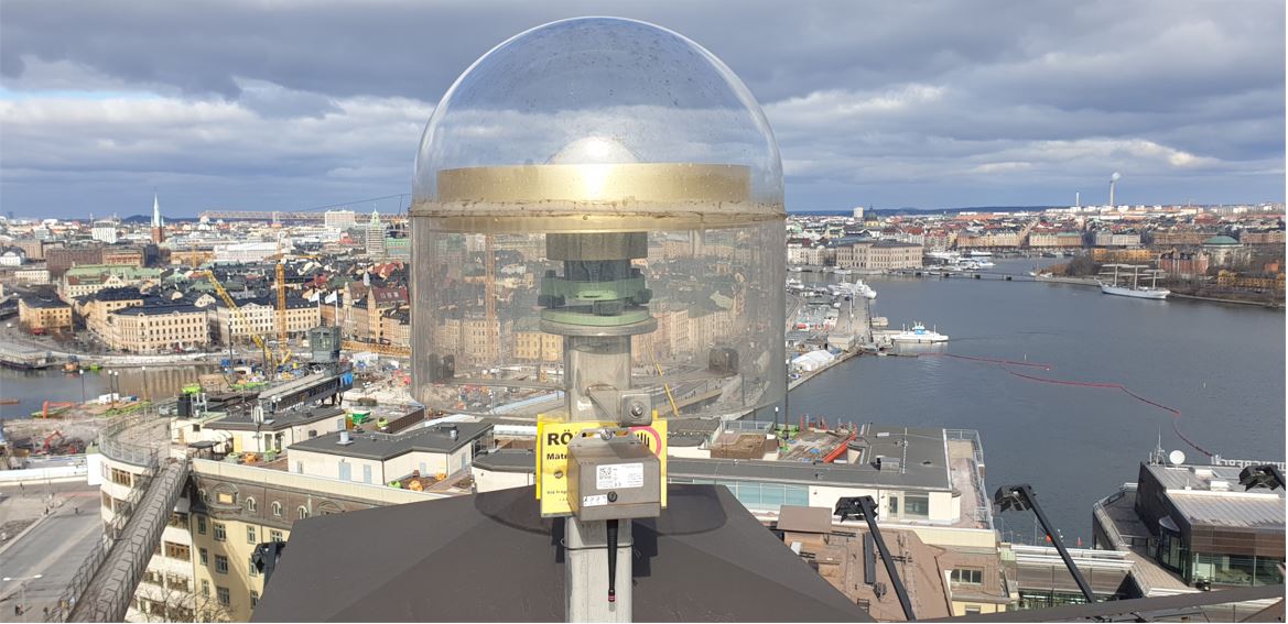
Framework in the air is a name for positioning infrastructure for major construction projects. It consists of a number of permanent GNSS stations, communication links and calculation routines. GNSS stations receive round-the-clock signals from all available satellites and distribute corrections to users via communication links.
Unlike the traditional backbone network, new backbone networks do not have to be so close and can therefore be outside the construction area, which in turn leads to them not risking disrupting work or being destroyed or moved. Milan Horemuz says that version 2.0 of the backbone network in the air was created due to the rapid technological development.
"The project is based on a previous project that was completed in 2011. As the goals, need and willingness to work more efficiently, uniformly, accessible and in as safe a way as possible still exist, the Swedish Transport Administration decided to develop a continuation of the first project. The conditions and needs for the project-adapted network have changed due to the rapidly advancing technological development. Satellite systems have changed with the addition of European, Chinese and Russian variants in recent years. All these systems are also constantly being modernized and with new signals come new opportunities to develop satellite positioning."
Physical measuring points can be moved or destroyed
The Reference Network in the Air can, among other things, help contractors, consulting companies and others involved to coordinate their activities at, for example, roads, railways, or where other similar different partners are involved. Part of that coordination is that everyone should work in the same coordinate reference system. The coordination must ensure that the construction falls in the right place on earth, in the right relation to other objects on the construction site. Milan Horemuz believes that there are disadvantages with traditional marking as the points must be physically marked within a construction site where a lot happens and many different moves. This means that they can be easily moved or destroyed, which can cause problems in further measurements and work.
"Sometimes the centimeters or millimeters may not play a bigger role, but sometimes they lead to bigger problems, which in turn can lead to financial losses if, for example, you have to demolish and rebuild or move building elements. For example, if you have a model and are going to build a new house with all the walls, electricity and water pipes. When several competencies are to collaborate in the same building, it becomes important that one management ends up in a certain room and not in another."
When processes are automated, it becomes important that everything is connected and ends up in the right place. Because of this, Milan and his colleagues look at several different aspects when it comes to the measurements. One of their main purposes is to propose, design working methods that are common to all parties in projects. This so that everyone who measures gets the same result, so that it does not differ depending on, for example, recipient or method.
The structure can be used over a long period of time
In addition to the Swedish Transport Administration's infrastructure project, Milan sees other usage data for the backbone network according to their original purpose.
"In the first place, this is of course for the Swedish Transport Administration's infrastructure project, but if you design routines for measurements, it would be a shame not to use that infrastructure for other purposes. Examples can be autonomous cars and machines that require high precision. Autonomous cars need a navigation infrastructure, which is the same as positioning infrastructure."
Factors that pose challenges for Milan Horemuz and his colleagues include everything from eliminating systematic errors in calculations, the ionosphere's electrical activity due to the sun, different ways to use measuring instruments and how reference points are placed in relation to the construction area to name a few. It is thus a hunt for millimeters with many different factors and several parties involved in the report.
The Reference Network in the Air project, Stomnät i Luften 2.0, started in 2019, runs over three years, and is financed by the Swedish Transport Administration. In addition to the Swedish Transport Administration and KTH, Lantmäteriet and RISE also contribute to the project.
Text: Hanna Kalla
This is the 16th article in the